Satellite technology detects illegal logging in Peru’s rainforest
As a result, over 41,000m3 of illegal wood has been seized between 2023 and 2024.
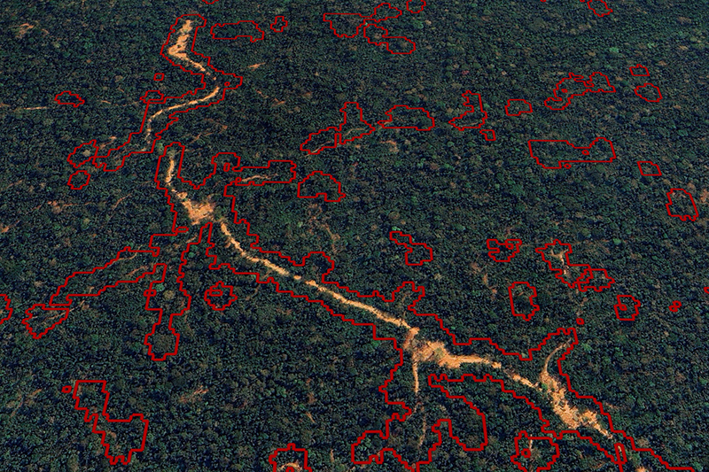
Changes in the forest canopy detected by satellites at one of the logging concessions in 2023, including the logging detections identified by the new algorithm in red
© Google Earth Image © Airbus 2025The team at the University of Sheffield, UK, designed digital tools that use a machine learning approach to accurately detect the removal of individual trees.
These can be used to assess forest degradation and provide evidence of selective logging and tree canopy loss.
Peru’s independent forestry commission (OSINFOR) says the technology has so far identified as much as 37% of all reported illegal logging across 1.8 million hectares of its rainforests.
Wood from rainforests is primarily sourced by selective logging, a technique that removes the most valuable trees from the forest, leaving the rest of the forest intact.
Selective logging occurs in up to 400 million hectares of tropical forest worldwide, an area the size of the EU.
However, because selective logging doesn’t fell large areas of forest indiscriminately, locating and identifying areas where it is happening illegally can be difficult to do from the air, and it takes extraordinary amounts of resources to monitor the forests on foot or with drones, which can also be dangerous.
Illegal selective logging has led to the removal of some of the forest's most valuable and ecologically important trees for export and sale on the global timber markets.
In related news, an Airbus-built, forest-monitoring satellite has been successfully launched into orbit in a European Space Agency (ESA) mission.
Launched on a Vega-C rocket from Europe’s Space Port, Kourou, French Guiana, the satellite Biomass will scan the Earth’s forests from an altitude of 666km during its five-year mission.
Biomass carries the first space-borne P-band radar, to deliver exceptionally accurate maps of tropical, temperate and boreal forest biomass to help improve understanding of the part that forests play in regulating climate.
Biomass will also measure paleo aquifers in desert regions to find new water sources in arid regions, as well as contribute to observations of ice sheet dynamics, subsurface geology and forest topography.
Biomass’ P-band radar will see through the forest canopy to the ground, improving current Digital Elevation Models in densely forested areas and provide a completely new view of the Earth’s surface.
The spacecraft features a large 12m deployable antenna to capture the reflected data to show changes in biomass due to forest loss (for example from logging/burning) and regrowth.
Development and testing of the Biomass spacecraft involved more than 50 companies across 20 countries.